On July 9, in the second year after Hurricane Sandy made landfall, Community Board 3 of the Lower East Side heard presentations about plans to protect their community from future storms and rising sea levels. Daniel Zarrilli, who runs the NYC Mayor’s Office of Recovery and Resiliency, introduced the Rebuild by Design BIG Team project, the Big U, and a study which evaluated the feasibility of a multi-purpose levee, previously referred to as Seaport City.
While the Big U and the potential multi-purpose levee are separate projects, the first phase of Big U starts just north of the seaport levee proposal, and ultimately the two designs will be integrated. They already share the goals of both enhanced flood protection and community development. The hope is that instead of just protecting from extreme weather events, the infrastructure will make the community more socially, economically, and environmentally resilient.
The combined presentation on July 9 emphasized that the design process will be a dialogue. This follows June push-back from board members in reaction to a rendering of the proposed seaport levee that included high-rise buildings. At the subsequent meeting, the Southern Manhattan Coastal Protection Study representative stressed that the image was a mere rendering, not a land-use proposal. The team plans to closely involve the community in their planning efforts, and as construction of the still-conceptual seaport levee will take decades, they will have the time.
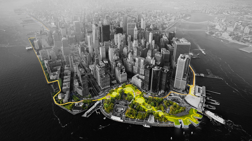
Jeremy Siegel, a designer at BIG, an architecture and urban design firm with offices in Copenhagen and New York City, then presented on the progress of the Big U, a protective system wrapping around lower Manhattan that is part of the City’s broader resiliency plans.
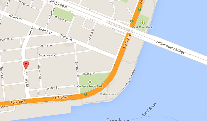
The Big U received the largest portion of funding in the Rebuild by Design competition, $335 million, and because of its location will likely be the most visible component of the Rebuild series of projects. Construction is expected to begin in the next few years on the first section, a segment that stretches from Montgomery Street, just south of the Williamsburg Bridge, north to 23rd Street.
“This is so exciting,” was the first comment from a board member after the presentation. The BIG team has engaged the community throughout their design process, including partnering with LESReady!, and at last week’s meeting, the community seemed satisfied with the current design. To succeed in creating coastal protection that also serves the people, levee projects will have to continue factoring in community concerns such as connectivity to the waterfront and the availability of affordable housing.
JEREMY SIEGEL has been a designer at BIG since 2010. The firm, headed by Bjarke Ingels who founded it in Copenhagen in 2005, is known for the award-winning Mountain Dwellings, the pyramidal housing coming to West 57th street, and other projects that include a waste-to-energy plant/ski slope. City Atlas spoke with Siegel about the design philosophy behind the Big U, the process of working with the community, and what New York City can learn from Copenhagen.
The Big U focuses on both flood protection and usable community space. You’ve mentioned how you chose to integrate the philosophies of both Robert Moses and Jane Jacobs. Did these two design goals ever conflict with each other? Did you ever feel like you had to compromise storm protection to create something the public would use and enjoy?
No, certainly not. I think where you have to negotiate those two things, you find unexpected solutions that you wouldn’t really imagine beforehand. Just to summarize the Jane Jacobs, Robert Moses idea in a different way, it’s part of a line of projects that we think of as social infrastructure: infrastructure that serves a utilitarian purpose, but that can also serve as an opportunity for people or for other activities that make it something that people can use, that people can understand, and that people can love 365 days a year.
One example of another project like this is a ski slope on a power plant that we’re constructing right now in Copenhagen, where we were asked to look at a waste-to-energy plant which has big buildings and a big smoke stack. We were asked to compete for, basically, a facade job that would beautify the plant. Rather than just beautifying it, we thought about how else that site could contribute to Copenhagen, and how it could be something that people could use. So, we actually proposed an artificial ski slope starting at the top, with a green, blue, and even a black diamond ski run, because you have a lot of snow in Copenhagen, but not a lot of topography.
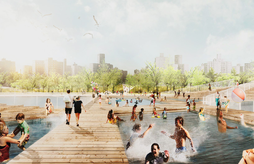
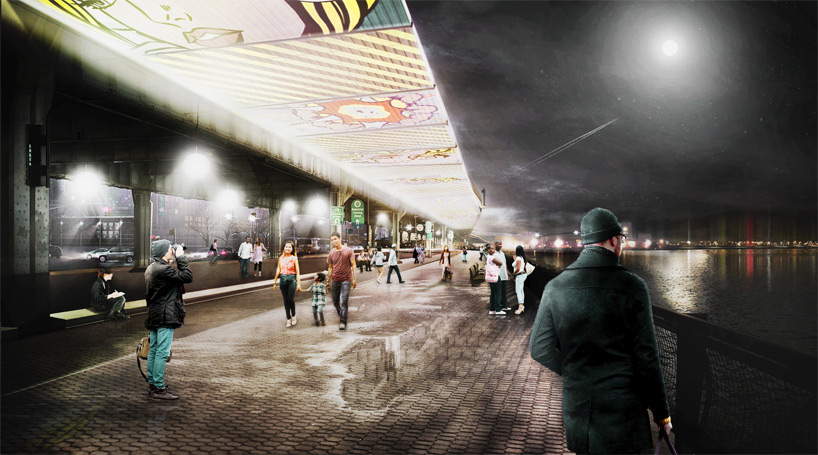
So, up and down the coast of the Lower East Side, we developed different ideas to respond to different concerns. For example, for the south what we heard was that views and security were a particularly sensitive thing, so all of our solutions there were aimed at maintaining visibility, and also security along the waterfront under the FDR, which is a place that faces some challenges already for access and security. We developed three options. One of them was a system of flip-down deployable panels that sit under the FDR and that flip down in the event of a storm.
When they’re not flipped down, they act as a canvas for public art for local artists, and they also have lighting integrated, so that it becomes this kind of secure ribbon of public space to walk through at night. Rather than being something that increases the problems with security there, it actually helps to make it a safer place.
We heard that it would be great to be able to accommodate more recreation, things like Ping-Pong and Tai Chi and basketball and skating under the FDR. So for that, we developed something called the Big Bench, which is a four-foot element that acts as a platform for all these different things. There’s seating, basketball courts, and so on. And because it’s only 4 feet tall, you can see over it. It also acts as a passive barrier for most storm events, but then in the case of a 100-year probability storm event, it acts as a foundation for a set of deployables. About 90% of the cost of a system like this is actually in the foundation, so if you have that already, that’s big.
That’s one example of how seemingly conflicting needs: the need to contribute to the urban environment and to provide use for people, and then the need to protect, actually come together in a kind of unexpected way when you try to solve them.
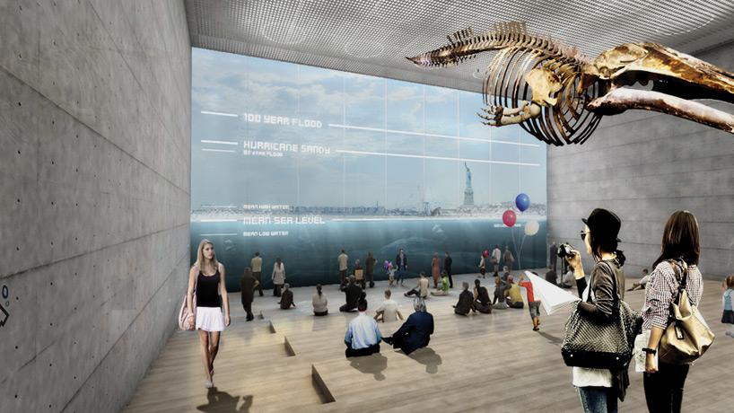
I read a quote from Bjarke Ingels, the founder of BIG, about how our society can change to become more sustainable. He said that, “It’s not about changing our behavior – it’s about designing our society in a smarter way.” I’m wondering if you think design can ultimately change behavior. For example, will the reverse aquarium that’s a part of the Big U encourage people to be mindful of climate change, and to, in turn, change their behavior? How can projects like the Big U alter our engagement with our surroundings?
I think totally, you can already see it happening a little bit in places. For example, Brooklyn Bridge Park is one of the first places along the waterfront in the city where you can actually get down close to the water, to the salt marsh, and it’s one of the most spectacular open spaces in the city right now. And that didn’t really exist a few years ago. So, I think you’re already seeing that kind of thing. Imagine if you didn’t have to go to the Hamptons to have a swim, but you could just hop into the East River. I think if you provide the opportunities for that kind of thing people will start to change their understanding of how to use the water, what the potential is of the water body that surrounds the city.
I think you picked up on what we were going for with the reverse aquarium, which is that you can actually, once you’re on the other side of the berm, observe tidal change and the gradual rise of sea level at the tip of this incredibly dense city. For us, that really brings it home, just as a matter of recounting the story, or allowing people to discover the story. There’s the simple fact that the edge of water is there at the glass, and if you start marking where it is now, where it is in a year, two years, three years, four years, five years, it’s evidence of something.
BIG is based in Copenhagen. What does New York have to learn from Copenhagen?
I think quite a bit. For one, in terms of relationships with the water. One of our first projects [in Copenhagen] was actually on the occasion of the water becoming so clean in the harbor that you could swim in it. We were asked to do a Harbor Bath, which we built and it’s a wooden structure that sits in the harbor that contains a series of pools, each one of them deeper, and the last one simply being the water of the harbor protected by this wooden structure with a diving board. It’s one of the best used places in Copenhagen in the summer. It’s a great thing to have access to the water in that way, and also to have access to the great things about being in a city, density and everything that comes with it.
I think another thing, of course, is the bike. It’s a very clean, healthy, and efficient way of moving around the city, and it’s key to moving around in Copenhagen – almost half the city bikes to work and school each day. So we have definitely been looking at every opportunity we can with the Big U to reinforce coastal bike connections, so any sort of a park along a berm we look at as a potentially beautiful, scenic bike path that could meander as the berm meanders, almost like in Santa Monica Beach or Venice Beach where you have these meandering bike paths.
That’s a matter of mobility, it’s a matter of getting cars off of the FDR because you can take a bike instead. The more cars we can get off the FDR, the closer we get to being able to close the FDR down or think about an alternative to giant highways on our coastlines. So you find that all these things are really linked.
The Big U received 335 million dollars of the Rebuild by Design Funding, but that won’t be enough to cover your full design proposal. HUD (the U.S. Department of Housing and Development, which funded Rebuild by Design) decided what part of your proposal to fund. What factored into this decision?
We did a conceptual cost estimate for all three compartments within the focus scope from Battery to 23rd. There’s one compartment running from 23rd to Montgomery, one from Montgomery to Brooklyn Bridge, and another running from Brooklyn Bridge to the Battery. Each work on their own to protect a separate piece of the city, and each can be built on their own. As proposed, each of the three compartments cost out between roughly 300 and 500 million dollars, and all told it’s about 1.2 billion dollars that we estimated to protect these four and a half miles of coastline. As part of that, we recommended that HUD fund what we thought would be a meaningful and implementable and functioning component of the plan, which was for compartment one, running from 23rd street to Montgomery.
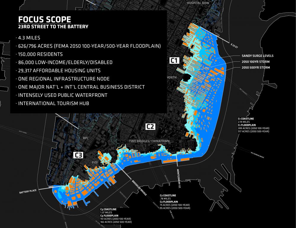
We identified that compartment for a few reasons. One is that it’s simply one of the deepest areas of the floodplain. There’s about 620 acres being protected there, about 130,000 people, 86,000 of whom are low income, elderly, or disabled. So, in terms of risk, both in the future and also as was demonstrated during Sandy, it made a lot of sense as a place to start.
The second piece of it was the fact that along almost one and a half miles of this 2.2 mile stretch, all the land ownership is contained within New York City Parks jurisdiction, which makes implementation a lot more streamlined. Having one client, one clearinghouse for all the logistical issues was an attractive thing. Because it’s also a mile and a half of a continuous condition, where you have a park, a highway, and a city, we had the opportunity there to do a project which is entirely passive. When I say passive I mean permanent in that it doesn’t require deployable elements at the intersection of the street grid and the water.
Along the Big U, wherever the street grid intersects with the water, we generally specify a deployable barrier in order to keep the views and access out to the water clear. That of course does pose challenges for maintenance, upkeep, and storage of those elements. Across the whole system, to reduce risk as much as possible, you want to put in place as much permanent, passive infrastructure as possible.
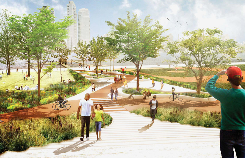
We’re able to do that with the East River Park berm because there is no access to the water to begin with. You have to get over the FDR, and you have to do that by bridge, so the berm is continuous and we’re actually improving connections to the water by introducing these bridges, which is why we call it the Bridging Berm. It’s also entirely earthen, which is proven to be the most straightforward and effective way of creating a storm surge barrier, with a wide earthen levee. And we also feel that it creates a great impact from an urban design perspective, just because of the unrealized potential of that mile and a half stretch.
One potential concern of a project like Rebuild by Design is that the adaptation to larger storm events distracts from climate change mitigation. As in, citizens relax because they feel like they are protected from the threat of rising sea levels, and then our society doesn’t transition away from fossil fuels, and we end up with even higher sea levels. Can an adaptation project like the Big U also contribute to climate mitigation?
Well I think it comes back to what we touched on earlier, where whenever we try to solve an issue of protecting a neighborhood we also try to solve other urban design issues in that neighborhood. I think that does come back to your point about mitigation because when you start to deal with transportation, which is always a concern along the coastline, because so much transportation infrastructure sits along the coastline, you’re immediately looking at ways to make use of space more efficient – biking for example is one way to do it.
Once you start getting people on bikes, and then you start getting autonomous vehicles in the city, even more opportunities open up. Autonomous vehicles are much more efficient, they can pack closely together, they offer a huge range of possibilities for decreasing the amount of area of the city that’s overtaken by highway infrastructure and road infrastructure.
You start to think, okay, what if in 50 years we need to expand this protective landscape to accommodate accelerated climate change? Or climate change decelerates but we simply need more public space for a growing population? You already start to think about how transportation and the transitions you make now might make those things easier in the future.
There’s also the addition of green space, both in the park and within the city itself, as a means of accommodating or managing storm-water capture of precipitation in a natural way, as green infrastructure. That’s a water management tool, but it also contributes to a healthier environment. It encourages exercise and being outdoors. It also tempers the climate in the case of both increased rain events and heat events, which then of course affects building performance, which in turns contributes to decreased greenhouse gas emissions.
I think one of the great things we’ve found about dealing with resiliency is that when you deal with resiliency at the scale of a neighborhood, you end up really working on everything about that neighborhood, because everything is so interlinked and water goes everywhere. So in that sense, adaptation and mitigation are not so separate.
Can you tell me a bit about the process of community engagement you had in the design of the Big U? What did you learn from working with the community?
After four months we had developed the idea for the Big U. We had developed some very initial ideas about how conditions might change along the 10 miles but we really hadn’t dug in yet. What HUD required of us immediately was to meet with every local, city, and state entity that might have anything to do with a project like this, and also, really importantly, the community groups in this focus area of the Lower East Side, which was a focus that was requested by the Mayor’s Office of Recovery and Resiliency. So we ended up meeting with 44 organizations in the course of 16 weeks, 22 government agencies, and collectively I think probably between 500 and 1,000 individual people by the end.
We actually were designing as we went. What we started with was looking at the waterfront and doing our own research to figure out what planning had been done in the past. That was the one of the things that the community organizations we worked with told us immediately, ‘We’ve had almost 15 years of planning here, and nothing’s happened. It would be good if you looked at these things and figured out what it is that’s come up time and again, and why it hasn’t worked.’ So we did that, and we started to get a sense of overall what the major planning intentions were for this area. It was about connecting back into the city better. It was about ecological restoration along the coastline. It was about more programming along the waterfront with free and non-commercial uses, better bike access, better public transit, etc.
And then we started to dig in just as designers. We started to say, ‘Okay what’s the range of possibilities here, from anything like a simple engineered flood wall, to something that incorporates elements of urban furniture, to something that’s more like a building, to something at the scale of a landscape, or even, what happens if we bury the FDR and put a protective park on top of that?’ So we made models of these things and we came to the community groups in a very open way. We said, ‘These represent the conditions, we don’t know what makes sense where yet, we have some ideas that we can talk about with you, but we really want to hear what you think about these things.’
That was the content of our first workshops and we really did come to some decisions – for example it was unclear whether a berm at the back or front of East River Park would make most sense. We slowly learned that the back of the park would make sense despite the fact that the park would flood increasingly. We learned that the city and the neighborhood were comfortable with the idea of the park gradually transforming over time – and that to maintain views from the park out to the water, and to maintain the recently built promenade would be a desirable thing.
So then we went back to the drawing board. It was actually an incredibly short amount of time, between our first round of design workshops and our second. It was a week and a half. That first week we basically just brought the whole team into New York, from the Netherlands, from Denmark, from around the city, and we walked up and down our four-and-a-half miles and we essentially, I would say there was a day when we really nailed down what, in broad strokes, the major design elements should be from 23rd Street to the Battery. And then we spent another week developing and visualizing them. Then we went straight back, because we didn’t have a lot of time until final, we went straight back to LESReady!, and I would say we did a workshop with about 60-70 people on the North side, and then the same on the South side, with that material. There we were able to get really specific feedback on how these things would affect very specific areas. We took that, and had about a month to develop that into our final proposal. That was our process.
But the challenge is really how to enhance the public’s relationship to the very water we’re figuring out how to effectively hold back. Of course to get this right, it will absolutely require shifts in how government agencies, municipal service providers who will maintain waterfront parkways and parks, and regulators, play a role today and how they help plan for the future. We’re excited to work with the city and with all of these players to imagine a range of new ways that cities can become more resilient economically, environmentally, and socially, and the Lower East Side is a great place to start.
2 Comments
Comments are closed.