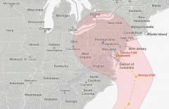
(Screenshot: New York Times Interactive Hurricane Map; 11 AM, 10/26)
New York City is in for quite a wallop from Hurricane Sandy, beginning on Sunday and lasting through Wednesday.
Twitter updates from the Mayors office will provide the latest info for city residents.
You can find your neighborhood on this map from WNYC, to see if your area is susceptible to flooding from a storm surge.
As of midday Friday, the center of the storm is expected to cross Delaware, and the rightward spiral (with the highest winds) will reach well up to NYC and Long Island. Rain will begin on Sunday, intensify on Monday, and the full force of the storm arrives Tuesday. Adding unpredictability is a cold front stalled over the Northeast, which may amplify the storm.
Meteorologist Jeff Masters sums up the scenario for New York City, referencing Hurricane Irene from last year, and the vulnerability of the subway system:
“The full moon is on Monday, which means tides will be at their peak for the month, increasing potential storm surge flooding. With Sandy’s strongest winds expected to last at least 12 hours near the time of landfall, the peak storm surge will affect the coast for at least one high tide cycle, and possibly two. This will greatly increase the potential for storm surge damage and coastal erosion. If Sandy hits Long Island, as the GFS model predicts, the storm surge will be capable of over-topping the flood walls in Manhattan and flooding portions of the New York City subway system. Fresh water flooding from heavy rains is also a huge concern. Rainfall amounts of 5 – 10 inches will occur over several hundred mile-long swath of coast, with isolated amounts of 15 inches possible. Fortunately, soils are dry and river levels are low over most of the threatened region, which should keep Sandy’s river flooding lower than that experienced last year during Hurricane Irene. Nevertheless, Sandy is shaping up to be a historic storm for the mid-Atlantic and Northeast U.S. that has few precedents.”